In June 2014, U-PARL acquired 180 maps of the Korean Peninsula dating to the colonial period (1910-1945) from the holdings of an antiquarian bookshop in Tokyo. We are proceeding to put the maps and envelopes in order, and are preparing the online release.
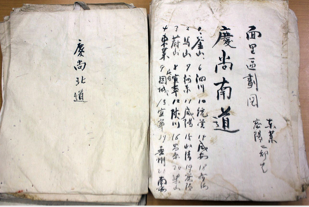
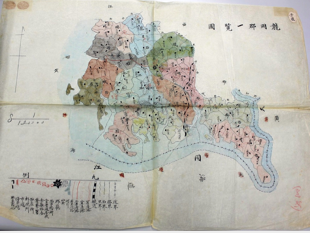
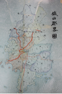
Most of these maps are thought to have been made by tracing district maps commissioned as part of the Army Land Survey on request of the General Staff of the Imperial Japanese Army (scale of 1/50000). Many map surfaces therefore feature a certain amount of coloring and writing. The maps cover all Korean provinces (道) with the exception of Hwanghae Province (黄海道). Covered are the following provinces: Gyeonggi-do (京畿道), Gangwon-do (江原道), Chungcheon-do (忠清南北道), Jeolla-do (全羅南北道), Gyeongsang-do(慶尚南北道), Pyongan-do (平安南北道), and Hamgyong-do (咸鏡南北道).
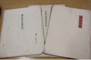
Some 50 envelopes were attached to the maps, in which the maps had likely been originally kept. Unfortunately, at the time of acquisition, the maps had already been taken out these envelopes. It is noteworthy that some envelopes feature writing, such as “Chūsūin (i.e., the privy council of the governor-general)” or “Plan of the Museum Garden,” which indicate that these maps were related to the office of the Governor-General of Korea (1910–45), the museum of the Governor-General of Korea (1915–45), and other institutions. Other envelopes bear notes such as “Survey of Customs,” “1916 Survey of Ancient Sites,” or “Materials Related to the Survey of Archeological Sites in Paekche,” which indicate that these maps were likely commissioned and used by the Chūsūin or persons tasked with historical surveys connected to the museum.