U-PARLは、2015年7月29日に中世エジプトの社会経済史研究で知られるスチュアート・ボーシュ氏を迎えて、講演会Nile Floods and Irrigation System Decay in Late Mamluk Egyptを開催いたします。
講演者であるスチュアート・ボーシュ氏(Assumption College)は中世エジプトの社会経済史を専攻し、マムルーク朝期を中心にナイル灌漑の歴史的展開、特に黒死病による人口減少との関係性や農業生産への影響についての研究を発表してきました。本講演会でボーシュ氏は、現在取り組んでいる最新の研究についてお話されるということです。その内容は、中世・西アジア史だけでなく、環境史学や考古学、地域研究、地理学といった他の分野に興味を持つ人をもひきつけるものになるでしょう。みなさまのご参加を心よりお待ちしております。詳しくは下記の講演概要をご覧ください。
【日時】
2015年7月29日(水)16:00–18:00
【会場】
早稲田大学 戸山キャンパス33号館6階第11会議室
(map: http://www.waseda.jp/top/assets/uploads/2014/02/150408_toyamamap.pdf)
【講演者】
Stuart Borsch, Assumption College
【使用言語】
英語
*本講演会はどなたでも参加可能です。より多くの方のご来場をお待ちしております。
*事前受付はありません。
*本講演会につきましてご不明な点がありましたら、担当者宛にご連絡ください。
担当者:熊倉和歌子(U-PARL特任研究員) kumakura.uparl[at]yahoo.com([at]を@に換えて送信してください)
【要旨】
Nile Floods and Irrigation System Decay in Late Mamluk Egypt
(Part of Nile Flood Profile Analysis, an ongoing collaborative research project)
This talk will address the ongoing project of Nile Flood Profile Analysis and explore its application to the subject of irrigation system decay in late Mamluk Egypt (1382 – 1517)
THE NILE IN FLOOD
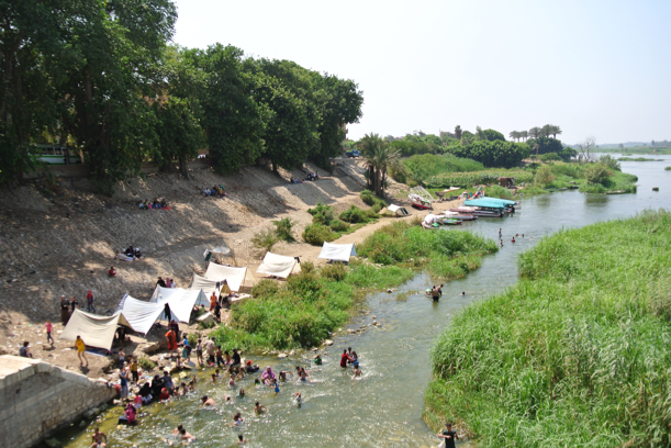
Before the construction of the Aswan High Dam in the 1960s, the annual flooding of the Nile was the fundamental basis of Egyptian civilization. The Nile floods came from the late spring monsoonal rains in Ethiopia that swelled the level of the Blue Nile and Atbara River. Floods levels were measured from a thirty-foot long limestone pillar standing in a deep stone well (the Cairo Nilometer). The Nile flood irrigated and fertilized Egypt’s agricultural land and made Egyptian civilization possible. Flood levels were recorded at the Nilometer from the seventh century to the twentieth century – setting down a historical record of floods that stretches back some 1,400 years. Nile floods were a subject of wonder and fascination long before the modern era. In fact, the study of the Nile floods dates back to ancient Egypt – and to Greek visitors like Herodotus. Some twenty four centuries after Herodotus, Nile floods continue to draw the attention of scholars. These floods are of great interest to scholarship today as they tell us so much about Egyptian history and the history of the global environment and climate.
NILE FLOOD PROFILE ANALYSIS
Despite the high level of scholarly interest in Nile floods, no one has ever systematically studied the profiles of Nile floods. Flood profiles, as defined for the purposes of this project, are the daily measurements of the flood’s height from the low water point in early June to flood recession at the end of December. Flood profiles tell us how much water was being discharged on any given day and thus whether the flood was a normal/moderate flood (a good flood) or an extreme flood (a bad flood – one that was too high or too low). The Nile Flood Profile Analysis project is the study of historical flood trajectories with the aim of learning more about the flood events and the enormous impact they had upon preindustrial Egyptian economy, society and polity. Nile Flood Profile Analysis examines these flood profiles via medieval Arabic texts, texts that narrate the flood events as they happened. It also builds computer simulations of the floods so that their trajectories can be studied quantitatively. Bringing together these elements from the humanities and the sciences, the project aims to enhance our knowledge and understanding of Egyptian history by studying the impact of these floods on the economy and society of Egypt. From the perspective of the sciences, the project aims at fashioning new tools for evaluating and measuring climate change and its impact on global warming via the method of using flood profile analysis to quantify the annual volumetric discharge of the Nile from approximately 600 CE to 1900 CE.
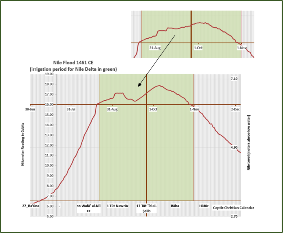
The methodology for Nile Flood Profile Analysis consists of building profile simulations taken from two directions; the baseline flood curve and the annual data. The baseline flood curve is single profile curve as calculated by the averaging of multiple sets of complete flood readings taken from medieval and modern records. The annual data consists of the partial flood readings for all flood years between 640 CE and 1904 CE. For some floods this data may be very scarce, for others we have more substantial data. The trick of the project is to bring these two together, the baseline flood curve and the annual data, so that the computer simulation can tease out the likely trajectory of the entire flood curve for every one of these historical floods. In the graph below, one can see such a case study, the result of bringing these two together for the Nile flood in 1461 CE. The cutaway shows a section of the original baseline curve, and the truncated flood rise displays a profile anomaly for that particular year, based on historical data from the Mamluk-era chronicler Ibrāḥīm Ibn ‛Umar al-Biqā‛ī (d. 1480).
NILE FLOODS AND IRRIGATION SYSTEM DECAY
In this talk, I will address aspects of this project that concern the Nile floods of the 1400s and the relationship of these floods with Egypt’s irrigation system decay. Scholars of Egyptian history are well aware that Nile floods had a very significant impact on the irrigation system in this period via the extreme high floods that often left in their wake substantial damage to the infrastructure of dikes, canals, and flood basins. What is not known is that the irrigation system itself had a major impact on Nile floods profiles. Due to extensive irrigation system decay in the fifteenth century, floodwater often escaped the system via gaps in dike containment barriers and the collapse of large dams and weirs.
The truncated path of the 1461 flood shown in the plot above was caused by the irrigation system itself. In this case damage to major irrigation channels in the eastern side of the Nile Delta and poor decision making on the part of the Mamluk irrigation authorities – governors, wālī(s) and inspectors, kāshif(s) – led to the opening of an enormous conduit of water by which a substantial portion of that year’s volumetric discharge was lost, estimated in the simulation as some one billion cubic meters of floodwater (in excess of one percent of the Nile’s average annual 84 billion cubic meter discharge). Major accidents like these, human impact on natural phenomena, have yet to be understood properly, but it seems clear from the evidence that there were a number of years in this interval in which human neglect of the irrigation system and human operating error caused substantial trauma to the Egyptian population and its material needs.
共催:早大中東イスラーム・セミナー、協賛:科学研究費助成事業(挑戦的萌芽研究)「環境・農業生産・記録管理ー文書史料に基づくエジプト環境史の構築ー」(研究課題番号15K12930)